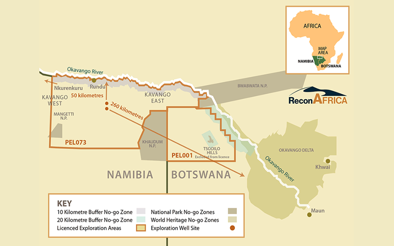
Reconnaissance Energy Africa Ltd has announced as a result of recent data from the ongoing phase two 2-D seismic program, a significant new play type has been confirmed in the southern and western parts of the Company’s ~6.3 million acre exploration licence area in Namibia – PEL 73. This new fold belt province, the “Damara Fold Belt”, initially identified SW of the Karoo Rift Basin, consists of a very prominent and clearly imaged series of anticlinal structures, also known as Whaleback anticlines.
These elongated anticlinal folds, which are often faulted, have a consistent linear trend in a NW to SE direction. With growing seismic data coverage used to identify these fold structures, 16 such structures have been recognized so far, with an areal extent of up to 50,000 acres (200 sq kms) and ~650 feet (200 metres) of column height, similar to structures found in the Zagros Fold Belt in Iran and Iraq (See maps & seismic).
The earlier phase of 2D seismic combined with stratigraphic test wells which penetrated the underlying Damara section (pre-Karoo aged stratigraphy), initially identified the fold belt below the Karoo Rift Basin and confirmed the trend and presence of these fold structures, carbonate reservoir rocks with up to 17% matrix porosity, fracture porosity, and significant oil shows (Netherland, Sewell & Associates Report). As per prior press release, gas samples from the most recent stratigraphic test well, sampled in Isotubes during drilling this (pre-Karoo) section, have been analysed by a third-party industry laboratory, GeoMark Research (Houston, TX), showing thermogenic methane gas and good concentrations of hydrocarbon gas liquids. Importantly, a natural gas seep has been located on top of one of these elongated anticlines.
Stratigraphically, the Damara section (pre-Karoo) is expected to contain multiple source rock intervals associated with glacial and post-glacial anoxic events, continental, and marine organic rich source rocks. It is expected the reservoirs and seals would be composed of stacked sequences of sands, limestones, dolomites and shales.
Extension of the phase two seismic program, which is currently being acquired, was designed to increase the seismic control, validate and delineate the full extension of this new play type. The 2D seismic data will be supplemented by a high resolution eFTG (Full Tensor Gravity) survey, recently permitted. An integrated interpretation of seismic, well data, eFTG and aero-magnetics has been prioritized and will enable three dimensional mapping of these large structures.
The Company has applied for drilling permits for six Damara locations, which are subject to further refinement once final data acquisition and interpretation are completed by July 2023. Subject to permitting, the Company expects to drill the first Damara Fold Belt location shortly thereafter.

Extension of the phase two seismic program was also designed to delineate the full extension to the southeast of the Karoo Rift Basin. Timing for additional Rift Basin wells, including previously announced 5-1 well in the Rift Basin, is postponed until completion of the seismic, the eFTG program, a full sequence stratigraphic integrated interpretation and the resulting prospect ranking for the entire licence area.
Seismic Operations
Acquisition of the Phase 2 extension 2-D seismic program (~1500 km) is on schedule to be finished in May of this year, completing the Company’s planned regional seismic acquisition program totaling ~2800 kms. This program expands 2D seismic coverage of both the new Damara Fold belt province and over the initial play, the Karoo Rift Basin, to the southeast corner of PEL 73. Results of the next well to test one of the structures in the Damara Fold Belt will be a part of the area wide risk weighted ranking of multiple play types, both in the Damara Fold Belt and the Karoo Rift Basin, which also remains highly prospective.
Petroleum Systems Analysis
Simultaneously, with the accelerated exploration focus on the Damara Fold Belt, a Petroleum System Analysis by a third-party specialist designed to evaluate the source rock maturity, generation and expulsion timing of hydrocarbons is also underway. This will be augmented by seismic sequence stratigraphic interpretation and mapping of the depositional environments to provide management with a more comprehensive understanding of the petroleum system, play fairway, and its variation within the entire Kavango Stratigraphic basin.
ReconAfrica is a Canadian oil and gas company engaged in the opening of the newly discovered deep Kavango Sedimentary Basin in the Kalahari Desert of northeastern Namibia and northwestern Botswana, where the Company holds petroleum licences comprising ~8 million contiguous acres. In all aspects of its operations ReconAfrica is committed to minimal disturbance of habitat in line with best international standards and will implement environmental and social best practices in all of its project areas.

Please wait....
Thank you for subscribing...