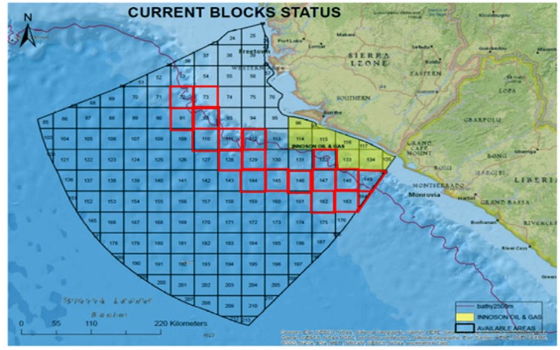
Fig WC1: WCAT study area indicated on PDSL (Petroleum Directorate Sierra Leone) base map. The 2500 metre bathymetric contour is in purple. The 20 Blocks covered are : 72, 73, 91, 92, 110, 111, 112, 128, 129, 132, 144, 145, 146, 147, 148, 149, 150, 162, 163, 164. Full blocks are ~ 1360 sq kms each. Blocks 149, 150, 163 and 164 are against the border with Liberia and are ‘part blocks’.
- Offshore Sierra Leone, situated on the West African Continental Margin and neighbouring Guinea and Liberia is, with only 8 wells drilled, a frontier exploration area for hydrocarbons.
- The 8 wells have been drilled on the shallow shelf and upper slope. 2 have encountered oil shows and 4 have been non-commercial oil discoveries. These have proved up a working hydrocarbon system.
Wildcat Petroleum’s Reconnaissance Licence (Desk Study) covers a ~ 24,000 sq km area (equivalent to ~ 18 complete Blocks – see fig WC1) in the deeper water (> 2500 m waterdepth) where the industry believes the potential to discover commercial hydrocarbons is greater than that on the shelf and shallow slope (Refs supplied in our associated pdf). Blocks will cover the Ultra-deep domains shown in
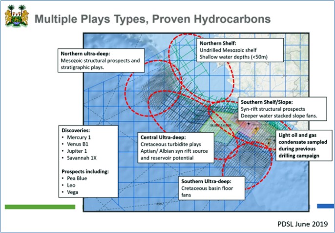
Fig WC2: This PDSL image shows the different geological domains (and the plays/prospects expected offshore Sierra Leone) – our study will cover blocks within the Ultra-deep areas. The image also shows the locations of the seismic data acquired off Sierra Leone. Plays will exist in both the pre-rift/syn rift (in the deep water to the NW i.e North of the main Sierra Leone Transform fault (Fig WC3) and in the post-rift both north and south of the Transform fault. {See Glossary and References in the associated pdf}.
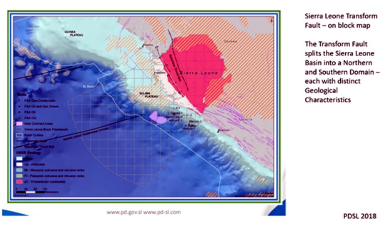
Fig WC3: This shows the location of the Sierra Leone Transform Fault. Other transform faults are also expected to be present.
- Regarding the post-rift plays, it is generally regarded (e.g Westwood Global 2020, Grand et al 2009, Amy 2019 and Sayers et al 2021) that larger discoveries will be made in deeper waters and that these will be in the large unconfined Lower Cretaceous fans which have been targeted successfully in discoveries stretching from Jubilee in Ghana to Liza in Guyana i.e in what we can recognise as a single Play Fairway – since before/during the breakup of Africa and South America, the Sierra Leone Basin and the Guyana/Suriname Basin were adjacent to each other i.e Conjugate – sharing the same rich source rocks and similar fan development (Fig WC4 and WC5).
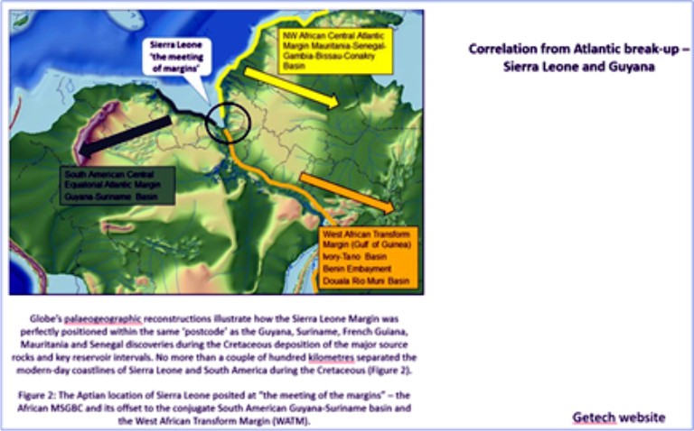
Fig WC4: Correlation from Atlantic Break-up – Sierra Leone and Guyana (from Getech website)
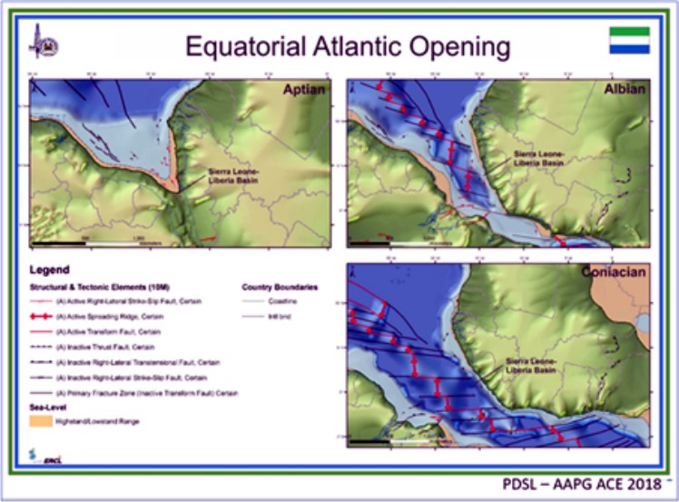
Fig WC5: Equatorial Atlantic Opening – PDSL (AAPG 2018) – source Getech
- Westwood Global’s 2018 analysis of drilling and success on the Central Atlantic Margin between 2007 (when Jubilee was discovered in Ghana) and 2018 discusses the lessons learnt from drilling this margin i.e modest success in many countries to date – but points out that only 12 wells out of 128 studied had been drilled into the ‘Basin Floor’ (i.e Toe of Slope – see fig WC6) but that these accounted for > 50% of the total discovered resources and have the highest success rates (Fig WC7)
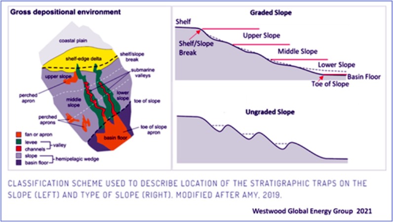
Fig WC6: Classification of stratigraphic traps on the Shelf Slope (from Westwood Global and after Amy 2019)
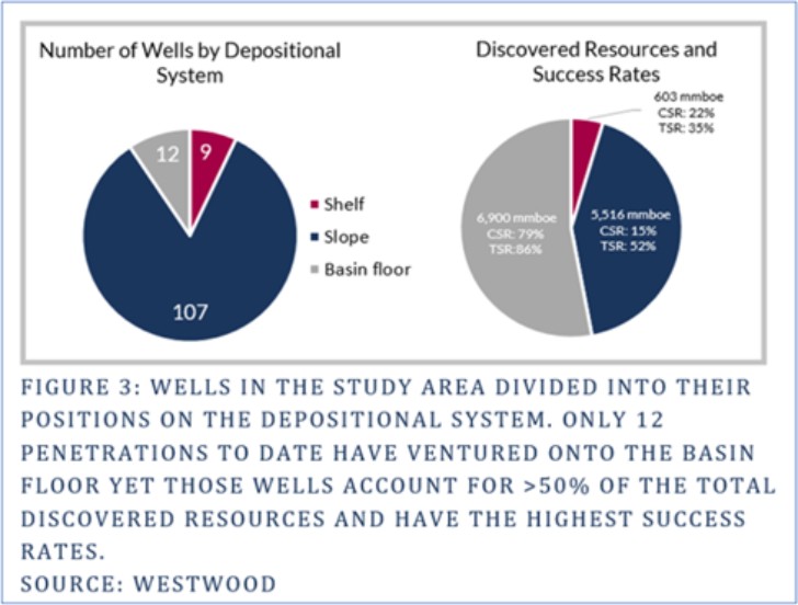
Fig WC7: Equatorial Margin – Classification of wells based on Shelf/Slope/Basin Floor (Westwood Global 2018)
- Wildcat’s study area will concentrate on this ‘Foot of Slope/Basin Floor area – as well as the potential to the north of the Sierra Leone Transform Fault where structural influences also come into play (Elenwa et al 2010, 2013 and undated).
- The hydrocarbon potential of the deepwater passive margin ‘foot of slope’/basin floor fans off Africa have been proved up recently with the recent multi-billion barrel Venus-1X oil discovery by Total and partners in the deepwater off Namibia.
- Regarding the potential of the ‘toe of slope’/basin floorfan plays off Sierra Leone, we can also note that African Petroleum in the acreage they were exploring in their deepwater blocks SL-03 and SL-4A-10, they recognised Prospective Resources of ~ 2.5 billion barrels in a number of large stacked fans (their 27/12/2017 press release) – before they exited in 2018. These fans are in what are now Blocks 130 and 131 – and are, we believe, subject to an application by another party. We would however expect to find similar fans along the same ‘foot of slope/basin floor fan’ trend. See figs WC8 and WC9.
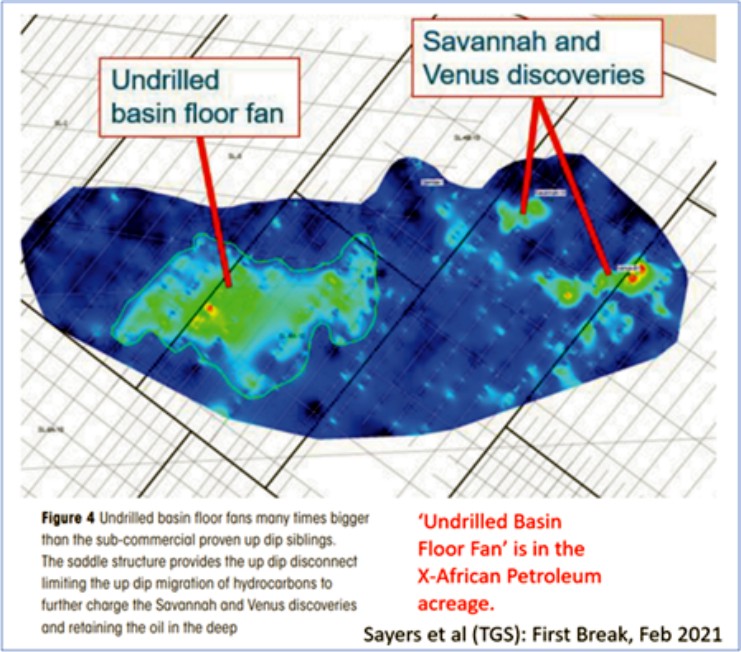
Fig WC8: A comparison of the size of the Savannah and Venus discoveries versus a mapped but undrilled fan in deeper water. Note also the comment about a the updip disconnect between the large deepwater fan and the shelf – limiting migration of oil shelfwards. Image is from TGS’s excellent Sayers et al 2021 article on the hydrocarbon potential offshore Sierra Leone and is gratefully acknowledged.
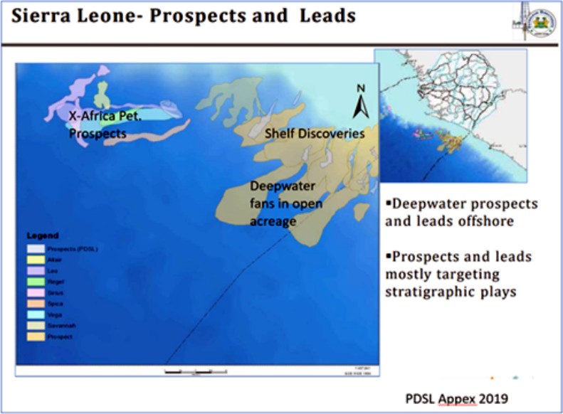
Fig WC9: Image from PDSL – with further annotation by Wildcat on some of the mapped prospects and leads in the Eastern part of our study area.
- Sierra Leone is regarded as having a stable legal and fiscal regime.
Further information on the Project Area including References and a Glossary can be found in a 17 page WCAT summary.
The summary was prepared in April/May 2022. Since then we have confirmed and expanded our ideas on the Study area and delivered a full report to the PDSL – see our 3 November 2022 RNS News item for the most recent status.
All information supplied above is in the Public Domain and referenced in the Summary Document. The use of figures from these websites and publications are gratefully acknowledged.
