


TGS, a leading global Norwegian multi-client geoscience data service provider for exploration & production (E&P) companies has announced the completion of its flagship Jaan 3D seismic survey covering the MSGBC Basin in NW Africa acquired in partnership with PGS and GeoPartners.
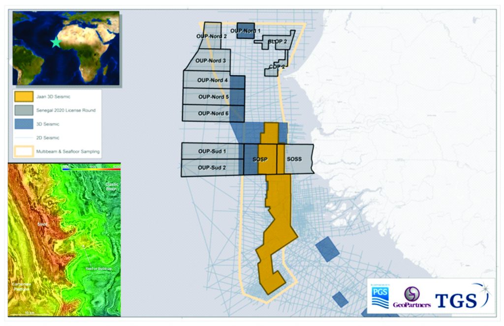
Comprising over 28,000 square kilometers, the vast survey spans across offshore Senegal, The Gambia, AGC and Guinea-Bissau was specifically designed to map the Cretaceous Palaeo Shelf-Edge Trend (PSET) and to shed light on untapped Jurassic potential. This has been the setting for the FAN and SNE discoveries, The Africa’s most successful play of recent times.
The vast Jaan 3D seismic program consists of both newly acquired (over 12,000 square kilometers) and recently reprocessed seismic surveys, having been processed and harmonized to create a seamless 3D PSTM and PSDM volume which allows explorers to obtain a holistic understanding of this prolific basin and its unique geological features of the shelf edge trend across borders.
The Jaan 3D also serves as basis for anticipated and ongoing bid rounds, including the Senegalese 2020 License Round, which offers acreage on-trend with the FAN and SNE discoveries. While the Gambia Jaan 3D seismic survey covers significant prospectivity similar to the FAR/Petronas targets in adjacent blocks.
“Recent and significant success in the MSGBC Basin demonstrates the importance of the province in terms of exploration not only in Africa but also worldwide. Learning from these giant discoveries and cross-border exploration success, the Jaan 3D survey has been specifically designed to highlight key play fairways and provide a vital exploration volume to enable E&P companies to unlock the next giant discovery.” Rune Eng, Executive Vice President, Global at TGS, said,
In furtherance to the Jaan 3D volume, the TGS subsurface data library in the MSGCB Basin includes over 82,000 km of 2D seismic and a further 16,000 square kilometers of 3D seismic (including newly acquired deepwater The Gambia and Senegal 3D surveys). This extensive and expanding seismic footprint is complemented by well data products and a vast 114,000 square kilometers Multi-Beam and Seafloor Sampling (MB&SS) survey covering Senegal to Guinea-Bissau.